
From under the old drawbridge at the Riverwalk, the Tombigbee River looks small and peaceful as it slowly flows toward Mobile. Yet for almost 500 hundred years that location has witnessed an almost unbelievable pageant of history. It is a world filled with history of Indians, Spanish conquistadors, the Civil War, steamboats and myriad notable events and people.
The earliest specific mention of the location that became the foot of Main Street in Columbus was by John Pitchlynn in 1817. In mid 1817 Captain Hugh Young, the surveyer of the route of Andrew Jackson’s Military Road, reached the Tombigbee River. In order to best determine a crossing point he met with John Pitchlynn, who lived at the north end of Plymouth Bluff near the mouth of Tibbee Creek. Pitchlynn was U.S. Interpreter and sub-agent for the Choctaw Nation in which he had resided since the 1770s. He had lived at Plymouth Bluff since 1810.
Captain Young asked Pitchlynn about the best place in the area to cross the Tombigbee. Young wrote to Andrew Jackson on September 30, 1817, with Pitchlynn’s response: “Mr. Pitchlyn joined me at the river, and recognized the place, as one used by the Indians for rafting, when the high water prevents fording at the usual places.” That recommendation established the location of the Tombigbee crossing of the Military Road. Pitchlynn’s comment also provided evidence for another crossing 277 years earlier.
In December 1540 the de Soto expedition arrived at the Tombigbee River, probably in the Columbus area. De Soto had an Indian guide and the Tombigbee was found to be overflowing its banks. A location was needed where both rafts could be built and the river crossed. The high water trail Pitchynn mentioned may have been in existence that early and so the Spanish crossing may well have been at the foot of present day Main Street.
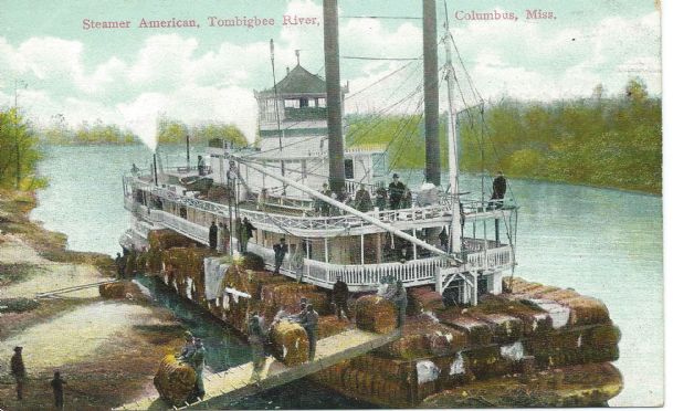
A house was built on the bluff overlooking the present day bridge site in late 1817 and in 1819 the Town of Columbus was established there. In 1822 the first steamboat on the Upper Tombigbee River, the Cotton Plant, arrived and landed just below the Military Road ferry. That location became the steamboat landing for Columbus, with the “Union Warehouse” constructed on the river bank at the end of 3rd Ave South. After the railroad was built to Columbus in the late 1850s a second landing was established at the new railroad trestle on the south side of town. Possibly the last steamboat disaster on the Upper Tombigbee occurred in 1911 when the side-wheel steamer City of Columbus burned and sank at the foot of Main Street.
During the Civil War the Confederate Army built a pontoon bridge across the Tombigbee in the area of both present day bridges. In October 1863, a report from a Union scout described the Confederate defenses at Columbus. He wrote: “The river is bridged with a very long bridge. Near the bridge is a small stockade, which can hardly keep twenty men in — a dash of 100 cavalrymen, can take it. The river can be forded at Main Street, but this ford is fortified with ditches and earthworks.” E R Hopkins, who lived in the Ole Homestead at 3rd and College Streets, during the Civil War recalled Confederate soldiers marching in front of his house going to and from steamboats docked at the river landing below the bluff.
The Military Road crossing of the Tombigbee was originally a ferry crossing at the foot of what is now Main Street. In 1842 the first bridge at Columbus was built by Horace King, a slave trained as an engineer. He was later emancipated and became one of the leading bridge builders in the South. The bridge was at the end of 4th Ave South and was torn down in the early 1850s. Then the Main Street ferry again became the principal river crossing. There was a pontoon bridge at the end of Main Street during the Civil War. After the war a ferry was put back in service and then in 1877 an iron bridge was constructed at the ferry site. It was replaced by a new drawbridge in 1928. In 1991 the present bridge to the Island was constructed and the 1928 bridge — soon to reopen as a pedestrian walkway — was closed.
The location of the beginning of the Riverwalk between the west ends of College and Main Streets overflows with history. There is even an account of two small cannon with Spanish coat of arms embossed on them being pulled out of the river in that area during the late 1840s. Their origin was unknown and they were lost during the Civil War.
People often ask me about historic markers. If one is needed anywhere it is needed on the Riverwalk at the foot of Main Street.
Rufus Ward is a Columbus native a local historian. E-mail your questions about local history to Rufus at [email protected].
You can help your community
Quality, in-depth journalism is essential to a healthy community. The Dispatch brings you the most complete reporting and insightful commentary in the Golden Triangle, but we need your help to continue our efforts. In the past week, our reporters have posted 41 articles to cdispatch.com. Please consider subscribing to our website for only $2.30 per week to help support local journalism and our community.
READER FAVORITES

Related Photos

A circa 1905 view of the iron bridge built across the Tombigbee River at the foot of Main Street in 1877. This bridge was replaced by a new drawbridge in 1928. Photo by: Courtesy photo
