
Recently I have been walking along the Riverwalk in Columbus. Anyone who has not walked that delightful pathway has missed an enjoyable merging of beauty, history and good exercise.
The Riverwalk is not only a touch of natural beauty at the edge of downtown it is also a place steeped in history.
It is a history that goes back almost 500 years. The earliest specific mention of the location that became Columbus and the Riverwalk at the foot of Main was by John Pitchlynn in 1817. In the summer of 1817, Capt. Hugh Young, the surveyor of the route of Andrew Jackson’s Military Road, reached the Tombigbee River. In order to best determine a crossing point, he met with John Pitchlynn, who was then residing at the north end of Plymouth Bluff. Pitchlynn was U.S. interpreter and sub-agent for the Choctaw Nation, in which he had lived since the 1770s.
Young asked Pitchlynn about the best place in the area to cross the Tombigbee. Young wrote to Andrew Jackson on September 30, 1817, with Pitchlynn’s response: “Mr. Pitchlynn joined me at the river, and recognized the place, as one used by the Indians for rafting, when the high water prevents fording at the usual places.” That recommendation established the location of the Tombigbee crossing of the Military Road and the future site of Columbus. Pitchlynn’s comment also provided evidence for another Tombigbee crossing 478 years ago this month.
In December 1540, the de Soto expedition arrived at the Tombigbee River somewhere between present day Pickensville and Aberdeen. De Soto had an Indian guide and the Tombigbee was found to be overflowing its banks. A place was needed where rafts could be built and the river crossed. The Indian high-water trail Pitchlynn mentioned may well have been that Spanish crossing place.
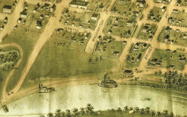
On the river bank at the end of College Street is a parking lot for the Riverwalk. From the parking lot along the walkway and under the two bridges was the site of Columbus’ early boat landing. As early as 1818 it was a keelboat landing.
The name and captain of one of the early keelboats was even provided in the Feb. 2, 1820, Mobile Gazette and Commercial Advertiser. It reported that the “barge” (keelboat) Southern Trader under Brown (Ovid Brown moved to Columbus in 1818 or 1819) had cleared the Port of Mobile headed for Columbus. In March 1823, the Cotton Plant became the first steamboat to arrive in Columbus and docked at the landing. That landing soon became a busy steamboat landing during the high-water shipping season of winter.
By the mid-1830s, warehouses were constructed along the river running south from the steamboat landing. Even today, in the thicket along the river just south of the Riverwalk parking lot, bricks can be found that mark the remains of the Union Warehouse that was constructed in the mid-1830s. That warehouse site was described by E.R. Hopkins in an article he wrote around 1930.
Hopkins had grown up in Columbus during the mid-1800s and in the 1920s and 30s often wrote about the Columbus of earlier years. In reminiscing about First Street South he wrote: “The other reminder is located on the bank of the river a little north of South Fourth Avenue. It is the north east brick foundation of the warehouse of B.L. Long & Son. This warehouse was destroyed (by a fire) with a large lot of cotton in 1880s. The volunteer firemen took the Lurlene Fire Engine down to the river and fought the fire. The cotton sheds were located where Mr. and Mrs. A.M. Byram’s dwelling stands (107 Fourth Ave. S.). A two room brick building on the same premises was used as a Camp House by people who hauled cotton in horse, mule, and oxen wagons from Fayette, Lamar, Pickens and other Alabama counties.”
Though apparently the remains are of the Union Warehouse, it is unclear as to who the original builder was. The earliest surviving Columbus newspapers date back only to 1836. The Nov. 12, 1836, Columbus Democrat has a reference to the warehouse of Clark & Co., and the Columbus Southern Argus in 1838 refers to warehouses of Clark & Co. and Aikin & Gibbs. Both warehouses were on the river at the steamboat landing and near each other. An ad in the Southern Argus issue described Aikin & Gibbs’ warehouse as “large, spacious and secure (being the one formerly occupied by C S Aikin).” The first mention I found of the name Union Warehouse being used was in 1848.
South of the warehouse remains and off of the top of the high river bluff, African-American engineer Horace King constructed a wooden covered bridge across the river in 1842. The recently restored old 1928 drawbridge crosses about where the upper limit of the boat landing would have been. It was about there that one of the last Upper Tombigbee steamboats, the City of Columbus, burned in 1911. The new Tombigbee bridge was built on the site of the 1877 iron bridge, which is also the old Military Road ferry crossing from 1817.
About 1848, two cannons, marked with Spanish crest, were found in the river near the boat landing; their origin was never determined and they were lost during the Civil War. During the Civil War the Confederate army constructed a pontoon bridge at the foot of Main Street with a small fort to protect it. Here, across on the west bank of the river, the wrecked hull of the Fanny W. was said to rest. She was a steamboat owned by African-American businessmen in Columbus. Her boilers exploded in 1878. Though almost to Waverly, the remains of her hull floated downstream and lodged against the riverbank across from Columbus.
There is a bridge on the Riverwalk crossing Moore’s Creek. This creek was first known as Tan Yard Creek. By the early 1820s there was a tan yard about where the soccer complex is now. Not far down the walkway is the Butterfly Garden. It is maintained by Lowndes County Master Gardeners. Spring through fall it is ablaze with color and filled with butterflies and humming birds. It is worth the walk just to enjoy the peaceful beauty it offers.
Walking through woods and sloughs along the walkway, one can ponder journeys taken by people seeking their freedom. The Underground Railroad, a branch of which came up the banks of the Tombigbee, was a route for escaping enslaved people to travel with the spiritual “Follow the Drinking Gourd” as a verbal road map.
An 1863 Confederate map shows entrenchments and fortifications extending across present day Highway 82 and the walkway to the river. There was an 1830s road running from Columbus generally along the present-day route of the walkway to the West Port Ferry. West Port was a cotton shipping community across the river on what is now the Island. The settlement was devastated by a flood in 1847.
A walk down the Columbus Riverwalk is truly traveling a pathway through history. And thanks to Carolyn Kaye for working with me and sharing some of the late Sam Kaye’s notes.
Rufus Ward is a Columbus native a local historian. E-mail your questions about local history to Rufus at [email protected].
You can help your community
Quality, in-depth journalism is essential to a healthy community. The Dispatch brings you the most complete reporting and insightful commentary in the Golden Triangle, but we need your help to continue our efforts. In the past week, our reporters have posted 37 articles to cdispatch.com. Please consider subscribing to our website for only $2.30 per week to help support local journalism and our community.


